Introduction
The Ministry of Culture and Media defines cultural landscape as a kind of immobile cultural good that contains historically characteristic structures which attest to human presence in the given territory, and which were shaped by a joint action of the man and the nature, witnessing to the historical development of a community and its territory. Although there are many types of cultural landscapes in the Republic of Croatia which constitute an important element of its spatial identity, the awareness of their existence and the need to preserve them is still low. In the process of abandoning villages, typical cultural landscapes disappear, along with characteristic flora and fauna.
The Protected Landscape of Barać Caves extends over an area of 5.19 km2, through three villages: Nova Kršlja, Stara Kršlja and Grabovac. This space abounds in archaeological findings, primarily found in caves that have been explored, which witness to a long period of human presence. The oldest finding is a bronze bracelet from 7th or 8th c. BC, and a lot of ceramics, weapons, and tools from later periods have also been discovered. Unlike some other parts of Croatia, where the population decline is mainly due to demographic transition and unfavourable economic conditions, this area has always been a challenging environment to live in. The reasons for this are numerous, from a land that is difficult to farm, over Ottoman attacks in the remote past, to the more recent military occupation in the Croatian Independence War.
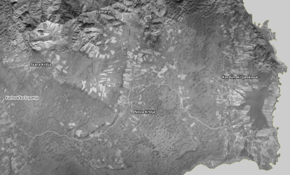
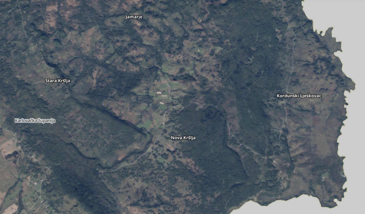
The population of Nova Kršlja, the village closest to Barać Caves, is nowadays the most numerous of the three villages and therefore has the greatest impact on the appearance of the cultural landscape of this area. In this article we will look at the area’s demographic characteristics and compare the digital orthophoto maps from 1968 and 2017/2018. It is important to note that, according to the data of the Croatian Statistics Bureau, the village of Grabovac has the most numerous population, however, the majority of its population resides along the State Road 1 and is not of great significance when it comes to the cultural landscape within the Protected Landscape of Barać Caves.
Analysis of the area’s demographic characteristics
The Municipality of Rakovica has recorded a continuous population decline since the census of 1931 (Figure 1). The only interruption in the negative natural growth and a very slight positive growth was recorded in the period between the censuses of 1948 and 1953, which may be attributed to the increased number of births (so-called baby boom) after World War II. The most dramatic population decline has been recorded in the inter-census periods during World War II and the Croatian Independence War. This was due to a decreased birth rate and an increased death rate, along with emigration. In addition to the population loss caused by World War II, in the post-war period emigration was further encouraged by the agrarian reform and colonisation in the period 1945–1948. The colonisation was conducted due to a lack of farmers and a great amount of land that was left without an owner (for the most part, the estates previously owned by Germans), which was to be inhabited by the population from other, agriculturally overpopulated, parts of the former state, including Lika and Kordun. Less than half a century from the end of World War II, the Croatian Independence War broke out, striking a final blow to the demographic picture of this Municipality. In addition to war casualties, there was a large-scale emigration of both the Croatian and the Serbian population.
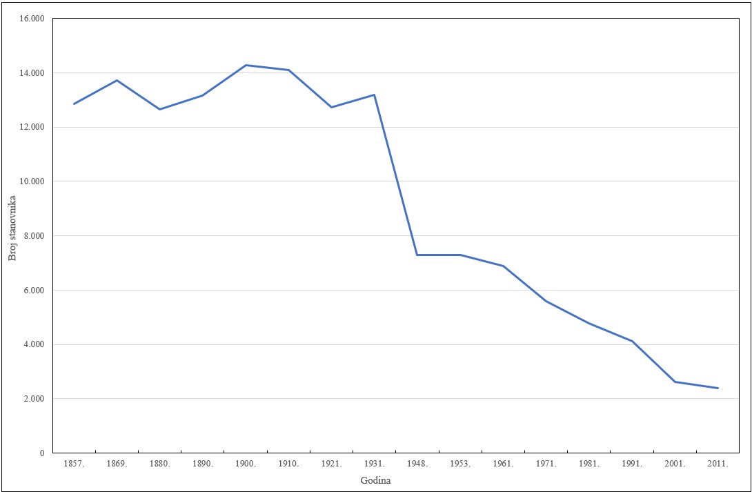
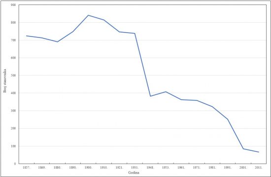
The population levels in the Village of Nova Kršlja are in line with those on the Municipality level. A significant factor characteristic for Nova Kršlja (as well as for the Municipality, albeit to a lesser extent) is the emigration of its Serbian population after the Independence War. According to the census of 1971, Serbian nationals constituted 67% of the village population (239 of the total of 358 inhabitants), and in 2011 the share of Serbs in the total population of the Municipality of Rakovica was 3.4 % (specifically, 77 inhabitants).
When the population is considered with regard to its economic activity, a great difference is evident between the two aforementioned census years. It should be noted that there have also been some changes in the census methodology, specifically in 1971 when agriculture and fishery were combined, while forestry was a separate category, whereas in 2011 all three activities were combined into a single category. In the 1971 census Nova Kršlja had only 166 persons employed in the agriculture and fishery sectors (and not a single person employed in the forestry sector), whereas in 2011 the Municipality of Rakovica recorded 46 persons employed in the agriculture, fishery, and forestry sectors. Furthermore, in the 1971 census, 61 of 75 households stated agriculture as a source of their income.
Analysis of digital orthophoto maps
The landscape value of this area is manifested in a mosaic-like succession of anthropogenically influenced habitats of meadows and pastures that are slowly covered by thickets, farmed land and degraded forests.
Figures 3 and 4 show the area of Nova Kršlja and the surrounding villages. It is evident that in 1968 considerably more land was farmed and that the area covered in forest and thicket was smaller. The reason for this change in the landscape is the depopulation of this area and the consequent deagrarisation process, which have lasted for decades. The period following the Independence War was characterised by a growing number of tourists visiting this area, which resulted in changes in the occupational and educational structure of the population and the movement away from agriculture.
The consequences of changes in the cultural landscape
An inventory of the flora and mapping of the habitats within the Protected Landscape enabled the determination of rare habitat types of both national and European significance. These are the following: reed beds, cattail beds, high nutsedges and sedges; wet meadows of Central Europe; moderately wet meadows; mesophile hay meadows of Central Europe; mountain meadows of upright brome on carbonate substrate; tall-herb habitats with meadowsweet; beech groves on banks; coastal flooded forests of beeches and poplars; mixed oak and hornbeam forests and hornbeam forests as well as beech forests with balm-leaved archangel. The preservation of said habitats requires special attention and they need to be maintained in a favourable conservation status as far as possible. An analysis of the habitats in this area demonstrated, as expected, the prevalence of forest habitats, as well as a large share of mesophile thickets and hedges of the submountain and mountain vegetation zone, and a relatively large share of mountain meadows of upright brome on carbonate substrate in an overgrown state, which are important habitats for orchids. Considering that this type of grassland (like most other types) is anthropogenic, this habitat type disappears as the human presence in the area decreases, which is sure to contribute to a decrease in biodiversity.
Conclusion
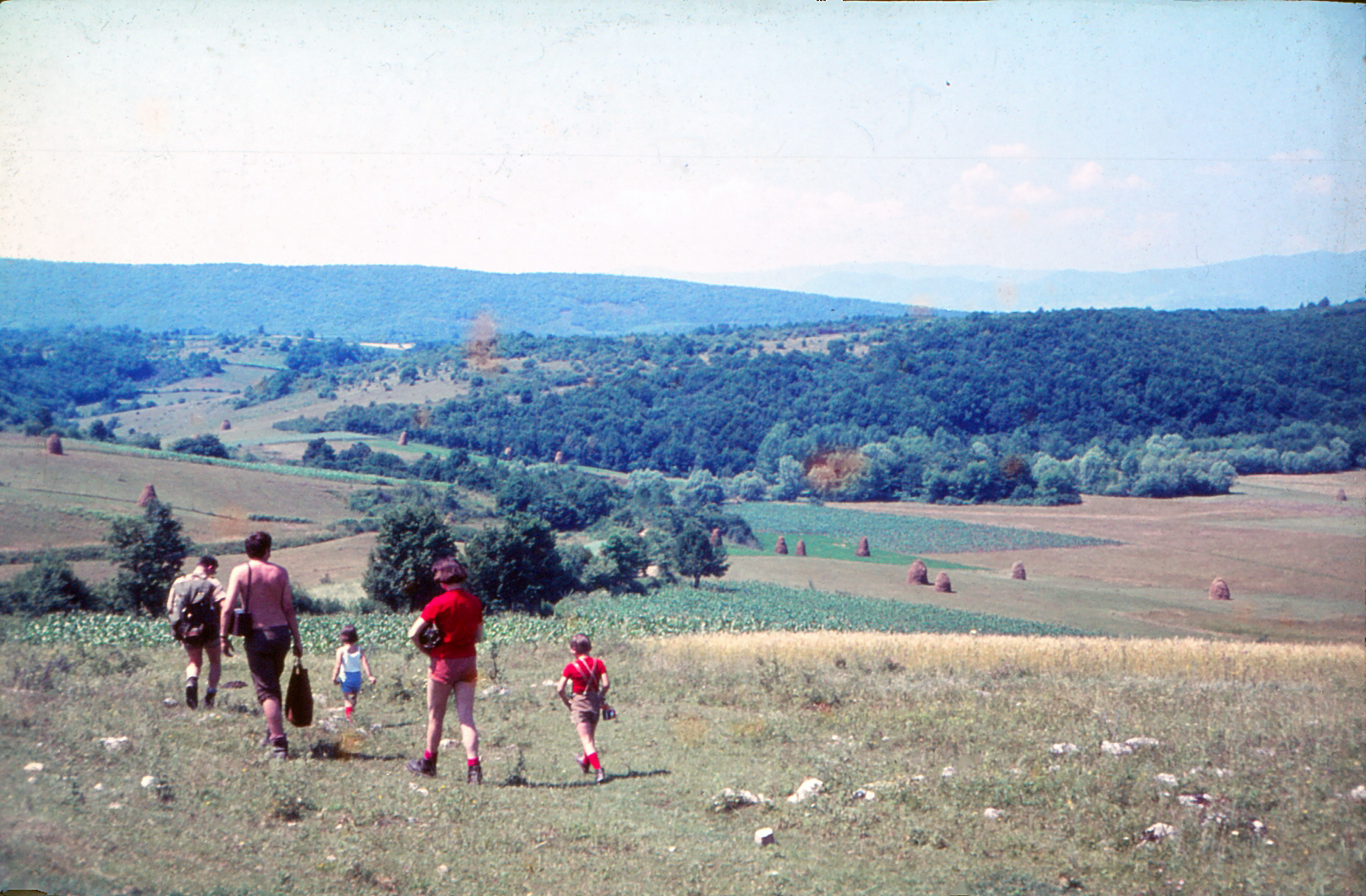
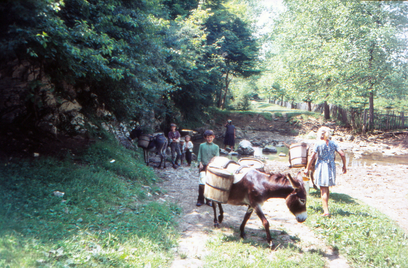
Our institution is aware of the consequences of the population’s movement away from villages and agriculture. In our work towards preserving the geomorphological and geospeleological values of this karst area, the mosaic-like landscape of natural and semi-natural habitats and its biodiversity, we are considering the option of encouraging the cleaning of overgrown areas and agricultural activities. We will make every effort to stop, as far as possible, the further progression of these trends in order to preserve the biodiversity and natural state of the landscape. The two photographs below were taken by the speleologist Vlado Božić in 1971 and they show what the area used to look like when agriculture was the fundamental activity.