Caves
Few countries in the world can boast so much karstland as Croatia, as over fifty percent of the territory of Croatia (including the seabed) is built from limestone. Limestone’s defining feature is being easily soluble in water. The joint action of the water and limestone creates a distinctive relief that features a large number of karst forms. In Croatia, karstland stretches from Istria and the Croatian Littoral, across Gorski kotar, Kordun, Lika, Dalmatia and its islands all the way to the border with Montenegro. It is an essential part of Dinaric karst, named after the magnificent mountain of Dinara which is located on the border between Croatia and Bosnia and Herzegovina, and featuring typical limestone characteristics. Several of the most typical karst forms are: karst fields, sinkholes, karren, subterranean rivers, karst springs, ˝mountain eyes˝, estavelles etc.
The hydrology of the karst is specific, with rivers and streams carving deep beds into the limestone, which often dive below the surface at the end of their course and continue their journey underground. This is one of the ways in which subterranean forms of karst – which are no less interesting than the ones on the surface – are developed. Exploring subterranean phenomena is the interest of speleology – the science that studies natural subterranean cavities. The longest cave system in the world are the Mammoth Caves in the USA, with over 600 kilometres of tunnels explored as of yet. In Croatia, 10000 caves and pits have been discovered so far. The longest cave system in Croatia is Kita Gaćešina – Draženova puhaljka on Velebit, which is over 20 kilometres in length. A great number of scientists from various disciplines contribute to revealing the secrets of the subterranean world, among which the most important are geologists, hydrologists, biospeleologists, meteorologists and, in particular, paleontologists and archaeologists, considering the fact that, in recent geological history, these caves served as a dwelling place and shelter for various animals and both prehistoric and modern man. Proof of this is most often found in the sediments near the entrances of caves, and also deeper in the tunnels. Barać Caves are the finding site of animal remains from the Late Pleistocene (cave bear, cave lion, rhinoceros, hyena, wolf…).
In Croatia, a large number of cave structures have been discovered that boast an abundance of cave ornaments, endemic cave fauna species (such as the olm) and valuable paleontological and archaeological finds. A small number of caves and pits have been opened to tourists. Some of the most famous caves that are open to visitors are Upper and Lower Cerovac Cave near Gračac in Lika. Here is also Vrelo Cave near Fužine and Lokvarka near Lokve in Gorski kotar, Vrlovka near Ozalj, Grgasova near Samobor, Veternica on the slopes of Zagrebačka Gora, Vranjača near Split, Biserujka on Krk and the only pit that is opened to visitors – Baredine Pit near Poreč. In addition to caves that have been fully equipped for tourist visits, there are also many that have been partially equipped for tourist visits, some of which were adapted back in the 19th century. The most famous of them are Samograd Cave in Perušić, and Barać Caves in Nova Kršlja near Rakovica in Kordun.
Caves in the Rakovica area
There are about 150 caves in Rakovica, most of which are still being explored. Some of the ones that are located at a greater depth are very rich in water, while others feature an amazing abundance of dripstones and archaeological remains. Due to the inaccessibility of the terrain, one of the rare caves that are available for the viewing pleasure of visitors are none other than Barać Caves. According to the locals, there exist two theories on how they were given their name. The first says that a villager named Barać heroically defeated a burly Ottoman soldier on the field in front of the caves, while the second says that, during the era of the Austro-Hungarian Monarchy, Hungarian soldiers referred to them as – friendly caves (barát = friend)!
Caves on the territory of the Protected Landscape of Barać Caves
The cave structures in the Protected Landscape have all been classified as caves. They are of various dimensions, with a length ranging from 23 m, which is the length of the Dry Valley Cave, to 519 metres, which is the length of Lower Barać Cave (it is worth mentioning that the length of the tunnel in the Baraćevac Spring Cave has only been estimated). The longest cave in the entire protected area is the cave system of Ponorac – Jovo’s Cave, with a length of 2834 m.
The entrances to the cave structures are located within a relatively small range of altitudes, from 295 to 345 metres, which is to be expected due to the relative flatness of the relief where caves predominate. One of the caves functions as a ponor (intermittently), two are springs (permanent), five used to be springs but are dry today, and only one of them has no paleohydrological function, past or present.
The cave structures of Upper, Lower and New Barać Cave and Baraćevac Spring Cave are located within the zone of Baraćeva Brina, in the northeastern part of the protected area.
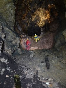
Upper Barać Cave
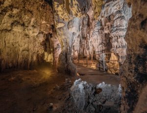
Upper Barać Cave features a regular cave entrance with a curved dome, with exposition of the entrance towards the northeast. Its dimensions are 4 x 4 metres, and it is located at an altitude of 495 m. It consists of several units. The first unit refers to the tunnel which stretches from the entrance towards the southwest in a length of 110 m. It reaches a width of nearly 10 m and a height of about 8 m. The tunnel is, particularly in its central part, rich in speleothems, of which stalagnates and stalactites distinguish themselves the most. These are very large stalagnates whose height at times exceeds 5 metres, while their diameter may exceed one metre. At the end of the tunnel, there is a pit that is about 7 m deep, whose bottom expands into a hall in which paleontological research was performed. The second unit has a length of approximately 50 m, while the width narrows to about 6 m, and the height increases to over 10 m. This part is also known as the Avenue of Academician Mirko Malez. At the transition from the first to the second unit, in the southern wall of the tunnel, there is an opening that connects with the parallel tunnel, i.e. the Lower Tunnel. This is the third morphological unit. The connection with the Upper Tunnel itself distinguishes itself with a very steep and rocky outcrop. This tunnel spreads out to both the east and west. The western part is about 6-8m wide, with a similar height.
For the first 20 or so metres, it stretches out horizontally, after which it steeply ascends for about 12 metres in the next 20 m. After this, the path is caved in, with visible roots, which leads to the conclusion that this is where one of the cave entrances used to be.
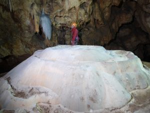
The eastern part steeply descends towards the east (for about 30 metres). The ceiling of the cave does not descend parallel to the floor, but slightly further to the east, creating a hall with a height of over 15 metres. Here is where one of the most beautiful dripstone formations in Barać Caves – Žrtvenik – is located. It’s a low form in the shape of a truncated cone, which was formed as the combination of a wide stalagmite with cascades on the rim, and it is white in colour. The fourth morphological unit in Upper Barać Cave represents a continuation of the main tunnel from the second unit towards the west. Its length is about 170 m, and it begins after the steep pit in the tunnel floor. This part of the cave differs significantly from the other units. It is significantly narrower (approx. 0.5 – 2 m), while the ceiling is quite high (up to 15 m). The floor of the tunnel is mostly flat, filled with sediment, and numerous bones are also located here. According to morphological type, Upper Barać Cave is considered a branched cave structure.
Lower Barać Cave
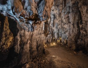
The dimensions of the entrance to Lower Barać Cave are 5.5 x 3 m, and the entrance is located at an altitude of 309.5 m above sea level. The total length of Lower Barać Cave is, according to most recent measurements, 519 m. The entrance is elliptical and regular in shape, mildly descending towards the interior in a funnel shape. The cave does not have any distinct morphological units. Generally, it stretches from the west to the northwest, but following a pronouncedly curvy path. In the first part, the curves are sharper, probably predisposed to cracking. In the continuation of the tunnel, the curves are rounder as a consequence of meandering. Around 60 m from the entrance to the main tunnel, it branches off into several very short branches, while the only secondary tunnel, which is 35 m in length, separates from the main tunnel towards the northwest at about 290 m from the entrance. The ceiling height varies throughout the main tunnel. The lowest parts of the ceiling are at about 0.5 m above floor level. At these locations, trenches were dug in the 19th century in order to facilitate movement. In the parts of the tunnel with a canyonesque morphology, the ceiling can reach a height in excess of 10 metres. The width of the tunnel also varies between approx. 1 metre and 5 metres. In the last part of the cave, there are two narrowings which are difficult to walk through. Lower Barać Cave is also rich in speleothems, out of which stalactites, stalagmites, pillars, flowstones and cascades distinguish themselves the most. However, the walls are covered with dripstone formations to a smaller extent than in the Upper Cave.
New Barać Cave
New Barać Cave is located in Baraćeva Brina, below Upper Barać Cave, at an altitude of 305 m above sea level. The dimensions of the entrance are small, and it was caved in up to 2003, when the members of the DDISKF (Society for the Research, Surveying and Filming of Karst Phenomena) discovered it and dug it up again. The total length of New Barać Cave is 94.5 m. The cave consists of a string of four subterranean halls connected with narrow passages. The cave stretches towards the west, descending 8 m down to the most distant and deepest point. This part is located just 1.5 m above the level of the water in Baraćevac Spring, where stalagmites and cascades particularly distinguish themselves. New Barać Cave represents the youngest inactive part of the cave complex of Barać Caves.
Baraćevac Spring Cave
The active spring of Baraćevac is located at the very foot of Baraćeva Brina, at an altitude of 295.5 m. The spring itself is completely submerged, which is why cave diving methods need to be utilised in order to explore it. The siphon at the entrance is about 40 metres in length, after which there is a tunnel of about 50 m that is not submerged, followed by 350 more metres of submerged tunnel – a siphon whose end researchers have not yet reached. As this cave is submerged for the most part and visibility is very poor, exploring it is extremely difficult. As topographic imaging has not yet been performed, we still lack more information on the morphology of the cave.
Ponorac Cave System – Jovo’s Cave
This cave system consists of two connected caves. The entrance to Ponorac was formed as the ponor of the Grabovac stream, although it today performs this function only intermittently. The first part of the cave is a 100-metre-long tunnel that leads from the entrance to what is today the main active tunnel –collector. In addition to the main tunnel, there are also many secondary tunnels in the cave, some of which are located at a level that is up to 10 metres above the main course. About 30 m from the main entrance (exit) to Jovo’s Cave, there is another smaller entrance measuring about 0.5 x 0.7 m. Although the system physically connects Ponorac with Jovo’s Cave, it is very difficult to walk through the structure. The greater part of the tunnel is covered in water that hides various obstacles, and between the two main entrances to the cave there are as many as 5 siphons. In addition to water, the system is rich in various dripstone formations, cave sediments, denudation forms (speleogens) and visible structural elements and other morphological and geological values, which makes it a one-of-a-kind phenomenon in the wider region.
Suvaja
Suvaja Cave is located near Jovo’s Cave. The entrance is small, oriented towards the southwest. The length of the cave is 77.6 m. It consists of several halls that are connected to each other with short passageways. Pottery remains have been found in them, together with some more recent objects, therefore the cave merits thorough archaeological research.
Dry Valley Cave
Very little information on this cave can be found in literature. The entrance is cave-type, measuring 2×1.5 m, with an exposition to the south, and it is located on the left slope of the dry valley between Ponorac and Jovo’s Cave. The length of the cave is 23 m, and it is located very close to the tunnels that are part of the Ponorac – Jovo’s Cave system, and it probably developed together with it. Fresh traces of wild animals have been spotted at the entrance, which points to the conclusion that this cave might have been used as a lair. The cave needs to be re-examined, after which a new topographic map should be created.
Cave with Pretty Entrance
This cave is located about 450 metres downstream from the entrance to Jovo’s Cave, on the right side of the valley of the Suvaja stream, and it has two entrances. The main entrance is cave-type, measuring 0.6 x 1.7 m. The other entrance is located above the main entrance, and it has pit-like characteristics and a diameter of 1 m. The cave has a length of 58 m, and cracks between layers dominate the morphology of the tunnel. Below the main entrance to the cave, there is a spring that flows into Suvaja after 40 metres. The cave most likely represents the fossil source of this course. It is necessary to create a new map of the cave.